Quantifying effects
of ammonia on soil in Scotland with different farming techniques.
The dissertation research project is about quantifying effects of ammonia on agricultural soil in Scotland due to different farming techniques. The research was about measuring pH levels from the collected samples of several organic and non-organic fields as well as performing quantitative analysis using ArcGIS while overlaying geospatial data for atmospheric ammonia in Scotland. The study concluded to observe that the pH levels of organic fields were found to be higher compared to conventional farms and agricultural ammonia was found to be lower than 1 tonne/km2 at 21 out of 29 organic farms
Precision Agriculture in Knock Farm
This project uses precision agriculture techniques for Knock Farm located in Huntly, Scotland. The project applies machine learning and classification techniques such as simple classification, supervised classification, unsupervised classification as well as applying classification with NDVI for the farm. The project also analyses available water capacity of each land parcel of the farm. The project also processes UAVs images captured for Knock Farm by using WebODM to combine multiple UAV photographs to produce an orthophoto, a DSM and a 3D model.
Site Suitability Analysis for Ideal location for a River Dam
The site suitability analysis project was about identifying suitable location where a dam could be built. Simply staring with an aerial photo, first geo-rectification of the aerial photo was done and elevation data were extracted from DXF file to create Triangular Irregular Network (TIN) and Digital Terrain Model (DTM). A lowest elevation point was identified and optimum dam size was determined. Finally, area of the expected reservoir was identified, sample polygons were drawn to identify vegetation cover as a training set for Supervised Classification technique to further locate all the affected vegetation under the reservoir region.
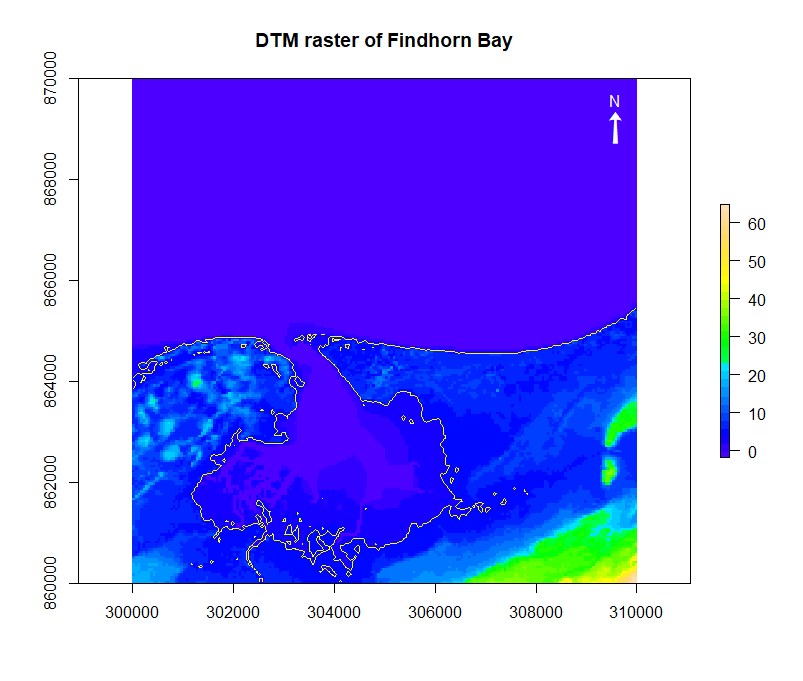
Sea level change modelling with R programming
A satellite image of a coastal town was accessed and digital terrain model was built using R programming. Range of elevations were identified and contours for different elevations were mapped. Map algebra was used to calculate the impact on town due to 4m rise in sea level water. The rasterised image with the sea level rise was also plotted on the map.
Multi-criteria GIS based estimation of coastal erosion risk
A review for a research paper written for creating a multi-criteria GIS based analysis model to determine the coastal erosion risk for sandy beaches. The purpose of the review was to critically evaluate the paper and discuss the methodology and results from the paper, and showcase the benefits as well as limitations of the paper in a poster while also suggesting what could be other alternatives for addressing a risk of coastal erosion.